The European Flood Awareness System (EFAS) is one service of the Copernicus Emergency Management Service (CEMS). It is designed to support preparatory measures for flood events across Europe, particularly in large trans-national river basins.
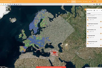
Information on upcoming flood events is provided through various products that are available on the EFAS Map Viewer. The following will provide you with an overview of the EFAS products, the underlying hydrological forecasting chain, and the Notifications of flood events which are based on the EFAS products.
The EFAS hydrological forecasting chain
The key elements of the EFAS production chain are: the meteorological forcing and land surface data; the hydrological models; and finally the EFAS forecasts and products.
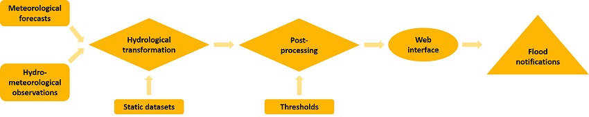
EFAS hydrological forecasting chain
The meteorological forcing and land surface data
The meteorological forcing data are all the information necessary to produce hydrological simulations. Historical hydro-meteorological time series records are used to calibrate and validate the hydrological model, the latter is used to define the flood thresholds used to derive EFAS products. Real-time meteorological observations are necessary to define the starting points of the forecasts, also called initial conditions. Historical and real-time hydrological observations are collected from national and regional agencies, and quality checked by the CEMS Meteorological Data Collection Centre (CEMS MDCC) and the CEMS Hydrological Data Collection Centre (CEMS HDCC) before being transferred to the CEMS Hydrological Forecast Computational Centre (CEMS COMP). Information on hydrological and meteorological data collection protocols, and on how to contribute to the EFAS hydrological and meteorological database can be found in this page: Share your data with EFAS.
Meteorological forecasts are used to provide the future meteorological input to the hydrological model. Different types of meteorological forecast forcings are used in EFAS: deterministic forcings (i.e. single realisation from a single model) and ensemble forcings (i.e. multiple realisations - also called ensemble members - from a single model). Probabilistic hydrological forecasts are issued based on the latter and give a quantifiable range of most probable future states.
The land surface data, including land surface information and model parameters, are all the information necessary to set-up and implement the hydrological models. Detailed information on these dataset are available from the following page: CEMS-Flood land surface data.
Hydrological model
Hydrological models transform the meteorological forecasts into hydrological forecasts by mimicking the hydrological land processes by a set of equations. In EFAS, the hydrological model OS LISFLOOD is used for medium- and seasonal-range forecasts, whilst conceptual hydrological algorithms are used for the flash flood indicators.
OS LISFLOOD is a spatially distributed rainfall-runoff-routing model. It has been developed by the European Commission Joint Research Centre starting from 1997, and has been used for operational flood forecasting at the pan-European scale since the beginning of EFAS. OS LISFLOOD source code, documentation, and user guide are available from the OS LISFLOOD repository.
EFAS Forecasts and Products
EFAS forecasts are produced by forcing the OS LISFLOOD hydrological model with a range of meteorological forecasts. EFAS forecasts include 6-hourly discharge time series for every grid cell of the river network, starting the day of the forecast and ending the last day of the meteorological forecast forcing.
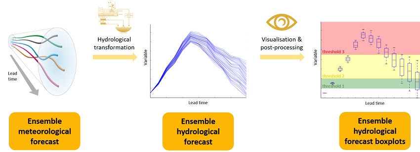
Schematic of ensemble forecasting
EFAS products are a set of maps and graphs that highlight possible future flood risk from the EFAS forecast simulations. They are produced by comparing the forecasts with reference flood thresholds, and categorised in different lead-time:
- Flash flood indicators: They provide indication of risk of flooding from flash floods, up to 5 days.
- Medium-range flood forecasts: They give overview of upcoming flood events for the next 10 days.
- Seasonal and sub-seasonal hydrological outlooks: They summarise the hydrological situation over the next 8 weeks.
Flood impact forecasts: They highlight regions with expected impacts in the next 10 days.
These products can be viewed in the Map Viewer under categories ‘Flood summary’, 'Hydrological' and ‘Flash Flood’.
Furthermore, EFAS products portfolio includes gridded dataset of modelled soil moisture (anomaly), snow water equivalent (anomaly), find more information in the Wiki under Initial Conditions Products Overview. These two key hydrological variables might trigger or increase the risk of flooding. Furthermore, these products are crucial to relevant applications such as the CEMS European Drought Observatory.
To respect Member States authorities regarding flood warnings, some EFAS forecasts products are only accessible to EFAS partners in real time. However, archived EFAS forecasts and products older than one month are freely accessible to the general public. To learn more on EFAS data restrictions and terms and conditions, visit the EFAS conditions of access page. Detailed information on how to access and use EFAS products and data can be found from the following page: Data access.
EFAS Versioning
EFAS system undergoes constant changes and improvements, both in the modelling system and the products that are produced for the web and web services. To make it possible for the EFAS users to understand and adapt to changes that might affect their work, all changes are collected into official EFAS releases and each release is given an EFAS version number. The version number has two digits, the first marks a major release, and the second a minor. A major release consists of changes that will affect the EFAS hydrological model results and hence forecasts. Please see our EFAS Wiki for more information EFAS versions and planned releases.
EFAS Flood Notifications and pre-tasking
EFAS Flood notifications are issued by the EFAS duty forecasters of CEMS Hydrological Forecast Centre - Analytics and Dissemination (CEMS DISS) to highlight potential future flood event. These notifications are sent to the EFAS partners and to the Emergency Response Coordination Centre (ERCC) of the European Commission. There are three types of notifications: Formal notification, Informal notifications (based on EFAS medium-range forecasts) and Flash Flood notifications (based on EFAS flash floods forecasts). EFAS partners and the ERCC can visualize the active notifications on the map viewer by activating the ‘Active Notifications’ layer. The historical archive of EFAS notifications is publicly available from EFAS Notifications Archive.
EFAS pre-tasking triggers satellite images acquisitions to proactively capture readings of an event in order to provide response agencies with timely satellite observation data, cutting down on collection and response time. EFAS pre-tasking workflow integrate the EFAS early warning service in the CEMS Rapid Mapping workflow. EFAS duty forecasters of the CEMS DISS monitor EFAS forecasts and compile the pre-tasking requests, including area of interest and time interval of the requested satellite acquisition. The pre-tasking request is then sent to the relevant EFAS partners, to the CEMS Rapid Mapping Authorized user, to the CEMS Rapid Mapping entrusted entity, and to the ERCC. EFAS partners are required to coordinate with the CEMS Rapid Mapping authorized user the decision on whether to request the activation of the CEMS Rapid Mapping Service for the acquisition of the satellite images. It is important to underline that pre-tasking requests do not automatically result in CEMS Rapid Mapping activations.