EFAS flyer and poster
![]()
![]()
Download: EFAS poster, EFAS flyer
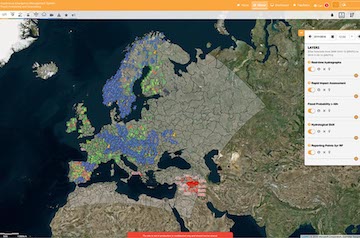
The aim of EFAS is to support preparatory measures before major flood events strike, particularly in the large trans-national river basins and throughout Europe in general. EFAS is the first operational European system monitoring and forecasting floods across Europe.
It provides complementary, added-value information (e.g. probabilistic, medium range flood forecasts, flash flood indicators or impact forecasts) to the relevant national and regional authorities. Furthermore, EFAS keeps the Emergency Response Coordination Centre (ERCC) informed about ongoing and possibly upcoming flood events across Europe.
Since 2012 EFAS is running fully operational as part of the Copernicus EMS. The Operational EFAS consists of four centres executed by different consortia:
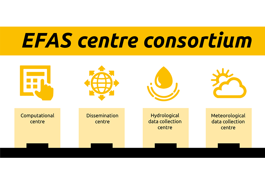
CEMS Hydrological Forecast Centre – Computation: European Centre for Medium-Range Weather Forecasts executes forecasts and hosts the EFAS-Information System platform
CEMS Hydrological Forecast Centre – Analytics and Dissemination: Swedish Meteorological and Hydrological Institute, Rijkswaterstaat and Slovak Hydro-Meteorological Institute analyses EFAS daily and disseminates information to the EFAS partners and the ERCC
- CEMS Hydrological Data Collection Centre: Ghenova Digital collects historic and real-time river discharge and water level data across Europe
- CEMS Meteorological Data Collection Centre: KISTERS AG and Deutscher Wetterdienst collects historic and real-time meteorological data across Europe.
How EFAS developed
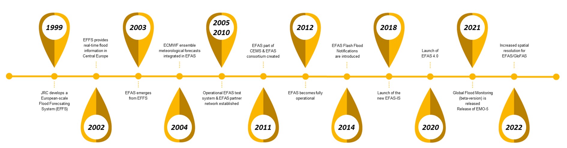
In 1999 the Joint Research Centre (JRC) of the European Commission started a research study for a European scale flood forecasting system (EFFS) in collaboration with national authorities and experts from different Member States.
The disastrous floods in Elbe and Danube rivers in 2002 confronted the European Commission with non-coherent flood warning information from different sources and of variable quality, complicating planning and organization of aid. The EFFS developed by the JRC successfully provided ad-hoc simulations of the ongoing floods and a forecast on how the flood waves could be expected to travel down the Danube river.
In response to this event and following a Communication of the Commission on the Elbe and Danube floods, the Joint Research Centre of the European Commission was assigned with the task to further develop EFFS into a fully operational, European-wide flood forecasting model. The first developments towards such a European Flood Awareness System (EFAS) were initiated in 2003, together with experts from Austria, Czech Republic, Germany, Hungary, and Slovakia and using forecasts from the German weather service.
In 2004 a collaboration agreement with ECMWF was signed, allowing the JRC to incorporate also ECMWF ensemble prediction data and its higher resolution deterministic forecast into EFAS in real-time.
From 2005 to 2010 EFAS was tested in real-time mode, together with the newly established EFAS partner network, consisting of national and regional flood forecasting authorities, and later also with the European Civil Protection.
In 2011 EFAS became part of the Copernicus EMS initial operations and in support to European Civil Protection. The operational components have been outsourced to Member State organizations.
EFAS is running fully operational since autumn 2012.
In 2014 Flash Flood Notifications were introduced.
The new EFAS-IS was launched in 2018.
A major release of EFAS (4.0) in 2020 included among others an increase in the temporal resolution of the forecasts (from daily to 6-hourly).
In 2021, a beta-version of the Global flood monitoring product was released as well as the EMO-5, a high-resolution multi-variable gridded meteorological data set for Europe.
For 2022, another major release of EFAS is foreseen including a higher spatial resolution (from 5-km to 1 arcmin, ~1.3 km).